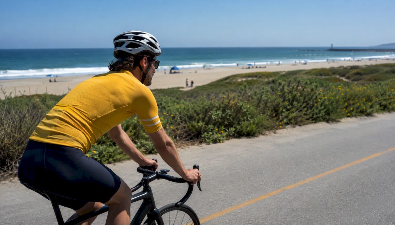
If you want to get rolling fast, start with these five routes and grab your maps from BikeLA and the LA County Bikeways Map before you head out.
Here are the top picks at a glance:
- Marvin Braude Bike Trail (The Strand): Best for coastal scenery. A paved coastal path hugging the shoreline from Will Rogers State Beach to Torrance Beach.
- San Gabriel River Bike Trail: Best for long-distance mileage. A long mostly flat, paved trail running from the mountains toward the coast.
- Los Angeles River Trail: Best for urban multi-use riding. A substantial paved path threading through the city with growing connectivity.
- Ballona Creek Bike Path: Best for a quick, family-friendly connector. Links Marina del Rey to Culver City with easy access to the coast.
- Orange Line / G Line Bikeway: Best for transit-connected commuting. Runs parallel to the Metro G Line through the San Fernando Valley.
For official maps, download the Metro printable PDF or open the interactive overlay at BikeLA, then cross-reference with the LA County Bikeways Map for project updates and closures. Both are free and regularly updated.
Key Takeaways
The best bike paths in Los Angeles pair well with official Metro and LA County maps, and matching your trail to your skill level and transit access makes the whole experience smoother.
| Point | Details |
|---|---|
| Download maps first | Grab the BikeLA PDF and open the LA County Bikeways Map before every ride to catch closures. |
| Match trail to your goal | The Strand for scenery, San Gabriel River for distance, G Line Bikeway for commuting, Ballona Creek for families. |
| Check agency closure pages | River trails close after rain; coastal paths close for events. Always verify before a long ride. |
| Plan transit and parking | Metro E and G Lines reach major trailheads; beach lots fill by mid-morning on weekends. |
| Report hazards to the right agency | LA County Public Works handles river trails; Beaches & Harbors covers most of The Strand. |
| Use Socalsights for turn-key routes | Curated day itineraries pair trail maps with food stops and local tips for a complete ride plan. |
Table of Contents
- Where do you find official bike path maps for Los Angeles?
- The top bike paths in Los Angeles: quick facts for every rider
- How to plan a ride in LA County
- Trail rules, maintenance, and how to report problems
- Which Los Angeles bike path is right for you?
- Why LA’s trails have gaps, and how to ride around them
- When is the best time to ride the bike paths in Los Angeles?
- Sources
Where do you find official bike path maps for Los Angeles?
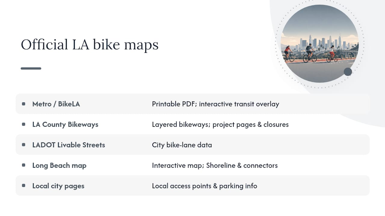
Getting the right map before your ride saves a lot of guesswork. LA County and the city each maintain separate resources, and knowing which one to pull up makes planning much smoother.
Metro / BikeLA maps are the best starting point for county-wide planning. The BikeLA map portal offers both a printable PDF and an interactive overlay that shows protected lanes, bike-friendly streets, and Metro rail and bus connections side by side. That transit overlay is genuinely useful if you plan to combine a bike ride with a train leg.
LA County Bikeways Map (hosted by LA County Public Works) gives you a layer-by-layer view of county-maintained bikeways, plus links to active project pages where you can check for construction closures or upcoming improvements. Bookmark dpw.lacounty.gov/bike/map.cfm for this one.
LADOT Livable Streets maintains city-specific bike lane data for the City of Los Angeles, which is helpful when your route dips into city-managed streets rather than county-maintained paths.
Long Beach has its own interactive bike map that covers the Shoreline Pedestrian Bikepath and local connectors. If your ride ends or starts in Long Beach, this is worth opening separately since county maps sometimes miss city-level detail.
Burbank and other cities often publish local access-point and parking info that county maps skip entirely. Check the individual city park or public works page when your trailhead sits inside a specific city.
Pro Tip: Download a printable PDF before you leave home, then keep the interactive map open on your phone for real-time navigation. Cell service can drop near river channels and underpasses, so having the offline PDF as a backup prevents a frustrating mid-ride detour.
Always check the agency’s maintenance or closure page before a long ride. River trail sections close periodically after heavy rain, and coastal paths occasionally shut down for special events.
The top bike paths in Los Angeles: quick facts for every rider
TrailLink’s regional guide and the LA County bike path inventory together cover dozens of named routes. The eight below are the ones most riders will actually use, covering everything from beach cruising to serious training mileage.
Access highlights by trail:
- Marvin Braude: Parking lots at Will Rogers State Beach, Santa Monica State Beach, and Hermosa Beach. Paid lots fill fast on weekends; arrive before 9 AM or take the Metro E Line to Downtown Santa Monica.
- San Gabriel River: The Wilderness Park trailhead in Azusa and the Seal Beach end near the Pacific Coast Highway are the most popular entry points. Free parking at both.
- Ballona Creek: Multiple street-level access points along Jefferson Boulevard and Slauson Avenue. The western end drops you right onto the Marvin Braude coastal path.
- G Line Bikeway: Every Metro G Line station has a bike path entry point, making this the easiest trail in the county to reach without a car.
How to plan a ride in LA County
Planning a ride here is a little different from most cities because the trail network is spread across multiple jurisdictions and the geography ranges from beach to river channel to suburban greenway. A few steps upfront make the whole thing much easier.
Step 1: Pick your trail and download the map. Use BikeLA for the interactive overlay, then save the relevant PDF section to your phone. For river trails, also check the LA County Bikeways page for any active closures.
Step 2: Decide how you’re getting to the trailhead. Metro rail and bus reach most major trailheads. Bikes ride free on Metro rail (folding bikes on buses), and most stations have bike lockers or racks. The Metro E Line drops you at Downtown Santa Monica, steps from the Marvin Braude path. The G Line runs parallel to its namesake bikeway the entire length of the San Fernando Valley.
Step 3: Check parking if you’re driving. Beach lots along The Strand charge fees and fill by mid-morning on weekends. River trail access points often have free street parking, but check posted signs for street-cleaning days and timed restrictions.
Step 4: Plan your turnaround or endpoint. Many LA trails are out-and-back, so your total mileage is double whatever you ride one way.
Three sample itineraries to get you started
-
Family beach loop on The Strand (8–10 miles, 1.5–2 hours): Start at Hermosa Beach Pier, ride north to Manhattan Beach and back. Flat, paved, and packed with snack stops. Arrive by 8:30 AM on weekends to beat the crowds near the pier.
-
Commuter out-and-back on the San Gabriel River (12 miles, 1–1.5 hours): Start at Wilderness Park in Azusa, ride south to Whittier Narrows Recreation Area, and turn back. Mostly flat with zero traffic interactions. Good for a weekday morning ride before the heat builds.
-
Training loop linking San Gabriel and Rio Hondo (30–35 miles, 2.5–3.5 hours): Start at Whittier Narrows, ride south on the San Gabriel River Trail toward Seal Beach, then loop back north on the Rio Hondo River Trail. Wind direction matters on this one: a south wind on the way out means a tough return, so check the forecast and start early.
Pro Tip: Coastal rides on The Strand almost always have an afternoon onshore breeze blowing from the south. Ride south first so the wind is at your back on the way home. Also check for any permitted events at the beach before you go — the Santa Monica and Venice sections can close to cyclists during large events.
Trail rules, maintenance, and how to report problems
LA’s bike paths are managed by a patchwork of agencies, and knowing who’s responsible for what stretch saves time when something needs fixing.
Common rules across most LA County paths:
- Yield to pedestrians at all times on shared-use paths
- Keep speeds reasonable in crowded sections (Santa Monica and Venice on The Strand get genuinely chaotic on summer weekends)
- Dogs must be on a leash on multi-use paths; some sections prohibit dogs entirely
- Class 1 and Class 2 e-bikes are generally allowed on paved multi-use paths; Class 3 e-bikes (speed pedelecs) may be restricted on some segments
- Motorized vehicles (other than permitted maintenance vehicles) are prohibited on all paved bike paths
- Helmets are required by California law for riders under 18; strongly recommended for all riders
Who maintains what:
LA County Public Works handles the river trails and county-managed bikeways. The Marvin Braude coastal path falls under LA County Beaches & Harbors for most of its length, though individual city sections (Santa Monica, Hermosa Beach, Redondo Beach) are maintained by those cities. The Ballona Creek path involves both LA County and the City of Los Angeles depending on the segment.
To report a hazard or request maintenance, go directly to the agency that manages that specific stretch. The LA County Bikeways Map project pages include contact information for county-managed segments. For city-managed sections, the relevant city’s public works or parks department is the right call.
Pro Tip: When you spot a pothole or a damaged barrier, take a photo with your phone’s location tag on. That makes it much easier to describe the exact spot when you submit a report, and agencies tend to respond faster to reports with precise location data.
Which Los Angeles bike path is right for you?
Matching the right trail to your situation saves you from showing up somewhere that doesn’t fit your group or your fitness level. Here’s a quick breakdown:
- Families with young kids: Ballona Creek Bike Path or the Shoreline Pedestrian Bikepath in Long Beach. Both are short, flat, and paved with minimal road crossings. The Shoreline path in Long Beach is especially relaxed and has the waterfront scenery to keep everyone happy.
- Beginners: The G Line Bikeway or the Expo Bike Path. Both are wide, paved, and have easy transit access so you can bail at any station if you’ve had enough. No elevation to worry about.
- Commuters: Expo Bike Path (Westside to downtown) or the G Line Bikeway (San Fernando Valley). Both run parallel to Metro lines, so you can ride one way and take the train back.
- Long-distance training: San Gabriel River Trail or the Rio Hondo loop. Flat, long, and mostly free of pedestrian traffic compared to the coastal paths. Watch for gaps near Whittier Narrows where the trail briefly goes on-road.
- Scenic leisure and photography: Marvin Braude Bike Trail. Ocean views the entire way, with iconic spots at Santa Monica Pier, Venice Beach, and the Palos Verdes cliffs in the distance from Torrance Beach. Go on a weekday morning for the best light and the fewest crowds.
- Urban exploration: Los Angeles River Trail. The river corridor passes Elysian Park, Griffith Park access points, and some genuinely interesting industrial-to-green transitions. Surface quality varies by segment, so check current conditions before a long ride.
Watch for surface transitions on the LA River and San Gabriel trails where paved sections give way to decomposed granite or gravel near some access points. Road bikes with narrow tires can handle most of it, but it’s worth knowing before you show up on 23mm slicks.
Why LA’s trails have gaps, and how to ride around them
One thing that surprises a lot of riders new to LA cycling routes is that the trails don’t always connect cleanly. You’ll be cruising along a beautiful river path and suddenly hit a fence, a construction zone, or a street crossing with no obvious continuation. That’s not a map error. It’s the reality of a network built across dozens of jurisdictions over several decades.
The Marvin Braude coastal path, for example, briefly goes on-road near Marina del Rey where the path crosses private marina property. The TrailLink route notes flag this section specifically, and it catches first-timers off guard. The fix is simple: follow the on-road connector for about a quarter mile and you’re back on the dedicated path.
River trails have similar quirks. The Los Angeles River Trail has segments managed by the City of LA, LA County, and in some stretches the Army Corps of Engineers, which means maintenance quality and surface condition can shift noticeably within a single mile. The LA County bike path inventory documents many of these segment-by-segment details, and it’s worth a quick scan before a new route.
Practical gap fixes:
- For the Marina del Rey connector on The Strand, use Via Marina or Admiralty Way. Both are low-traffic and well-signed.
- On the LA River Trail near downtown, Riverside Drive serves as the most common on-road connector between trail segments.
- When the San Gabriel River Trail gaps near Whittier Narrows, Rosemead Boulevard is the standard street connection.
Pro Tip: Before any ride longer than 15 miles, pull up the specific trail page on TrailLink and read the route notes, not just the mileage. The notes flag on-road connectors, pedestrian-heavy sections, and surface changes that the official maps often don’t show.
Socalsights pulls community-reported access tips from local riders who know these connectors firsthand. If you’ve found a better gap fix or a new access point, that kind of local intel is exactly what makes these guides more useful for everyone.
When is the best time to ride the bike paths in Los Angeles?
LA’s mild climate means you can ride year-round, but the experience varies a lot by season and time of day.
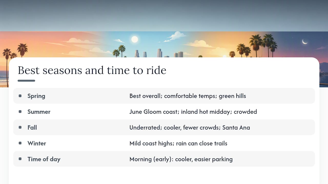
Spring (March through May) is widely considered the best overall season. Temperatures are comfortable, the hills are green, and the marine layer usually burns off by mid-morning. Coastal paths are busy but not yet at peak summer crowds.
Summer (June through August) brings the famous “June Gloom,” where the coast stays overcast and cool until late morning. That’s actually great for riding. Inland trails like the San Gabriel River get hot by midday, so early starts (before 8 AM) are worth it. Coastal paths get genuinely crowded on weekends, especially the Santa Monica and Venice sections of The Strand.
Fall (September through November) is arguably the most underrated time to ride. The marine layer clears, temperatures drop slightly, and the crowds thin out after Labor Day. The Santa Ana winds can pick up in October and November, which creates strong offshore gusts. Riding inland on those days is more comfortable than fighting a headwind on the coast.
Winter (December through February) is mild by most standards, with daytime highs often in the 60s°F along the coast. Rain is infrequent but can close river trails quickly when it does arrive. The LA River and San Gabriel River channels drain fast, but trail surfaces can stay muddy or debris-covered for a day or two after significant rain. Check the LA County Bikeways Map for closure notices after any storm.
The best time of day, regardless of season, is early morning. Parking is easier, temperatures are lower, and the coastal light is genuinely beautiful before the beach crowds arrive.
What I keep coming back to about riding in LA
There’s something about the Marvin Braude path on a Tuesday morning in October that you just can’t replicate anywhere else in the country. The marine layer is still hanging low, the path is quiet, and you can ride from Will Rogers State Beach all the way to Torrance without stopping at a single traffic light. That’s a rare thing in a city this size.
What I’d love to see more of is community-sourced route intel. The official maps are solid, but they don’t tell you that the parking lot at Hermosa Beach fills by 8:30 AM on a Saturday, or that the connector through Marina del Rey is smoother if you take Via Marina instead of the marked route. If you’ve got a tip like that, a better access point, a gap fix, or a lesser-known trailhead, send it our way. That’s exactly the kind of local knowledge that makes these guides actually useful.
Curated ride itineraries from Socalsights
Socalsights puts together curated day itineraries that pair the best LA cycling routes with local food stops, scenic detours, and practical logistics so you’re not piecing it together from five different tabs.

Whether you want a full beach-day loop on The Strand with a lunch stop in Hermosa, or a longer river trail ride with a coffee detour in Culver City, the Socalsights guides handle the planning so you can focus on the ride. Check out the 100+ SoCal Sights list for ride-adjacent spots worth building a day around, or grab a Socalsights membership for access to the full library of curated routes and community tips. Head to the site and find the itinerary that fits your next ride.
Sources
These are the pages worth bookmarking before your next ride. Use the agency pages for closures and the map portals for planning.
For closures and maintenance notices:
- LA County Bikeways Map
- LA County Beach Bike Path – Beaches & Harbors
- Bike Maps | BikeLA
- Ballona Creek Bike Path — LA County Trails
For route planning and printable maps:
For trail discovery and route research:
Use the agency pages (Beaches & Harbors, LA County Bikeways, Ballona Creek trail page) to check for closures. Use BikeLA and TrailLink for planning and route discovery.